The 1930s are Still in the Budget: Announcing the Flint Spatial Echo
- Rajah Smart

- Apr 1
- 2 min read
Today, we are proud to announce the public release of the Flint Spatial Echo, an interactive geospatial tool designed to make visible the hidden structural ties between 1930s federal housing policy and 21st-century school funding. For too long, the fiscal struggles of districts like Flint and Beecher have been dismissed as local mismanagement. This project provides the empirical evidence to refute that narrative, demonstrating that geography is not a neutral backdrop—it is a central mechanism for resource hoarding and capital extraction.
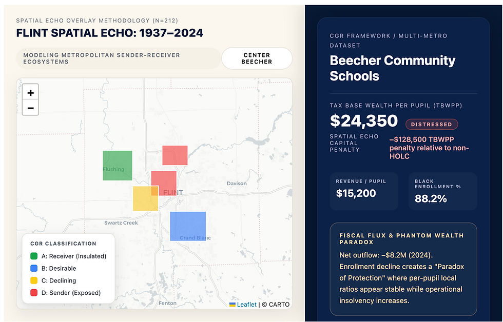
Our multi-metro analysis of approximately 212 Michigan school districts reveals a quantifiable spatial echo. Districts tethered to historically redlined HOLC D zones carry a substantial fiscal penalty. According to our recent findings, these districts exhibit roughly $128,500 less tax base wealth per pupil (TBWPP) than their non-redlined counterparts, even after controlling for contemporary racial and socioeconomic factors. This structural deficit is what Ladson-Billings (2006) describes as the cumulative education debt owed to marginalized communities (https://www.tnefp.org/flintmap).
Making the Invisible Visible
The Flint Spatial Echo tool allows users to explore these metropolitan ecosystems in real time. It specifically highlights the sender-receiver model, where state revenue tied to mobile students systematically flows from high-exposure, majority-Black sender districts to historically advantaged receiver districts (Smart et al., 2023). While the state aid travels with the student, the legacy fixed costs—such as oversized infrastructure and pension liabilities—remain trapped at the origin.
The tool also helps users identify the phantom wealth paradox. This phenomenon occurs when steep enrollment declines artificially inflate per-pupil local revenue ratios in distressed districts, masking operational insolvency and creating a false appearance of fiscal protection. By visualizing these dynamics, we move beyond generic urban-suburban labels and follow the actual racialized space where policy impacts are felt.
A Vision for Regional Expansion
While this phase focuses on the Flint metro area and broader regions of Michigan, our goal is much larger. We are building a scalable model to map these spatial echoes across the Midwest and the Southern states. The architecture of inequity is not unique to Michigan; the cartography of risk established by the Home Owners’ Loan Corporation created a national blueprint for disinvestment that continues to reverberate through school finance systems across the country (Rothstein, 2017).
We invite you to explore the data, engage with the maps, and join us in reframing the conversation around school funding. Our boundaries should not function as economic walls. By documenting the spatial echo, we take the first step toward building a funding regime that finally confronts land-based inequity.
References
Ladson-Billings, G. (2006). From the achievement gap to the education debt: Understanding achievement in U.S. schools. Educational Researcher, 35(7), 3-12. https://doi.org/10.3102/0013189X08326465
Rothstein, R. (2017). The color of law: A forgotten history of how our government segregated America. Liveright.
Smart, R. E., Caldwell, P., Richardson, J. T., & Sim, G. (2023). The crisis of Michigan's public school funding and its influence on human resources management. Journal of Education Human Resources, 41(3), 477-513. https://doi.org/10.3138/jehr-2021-0066

Comments